
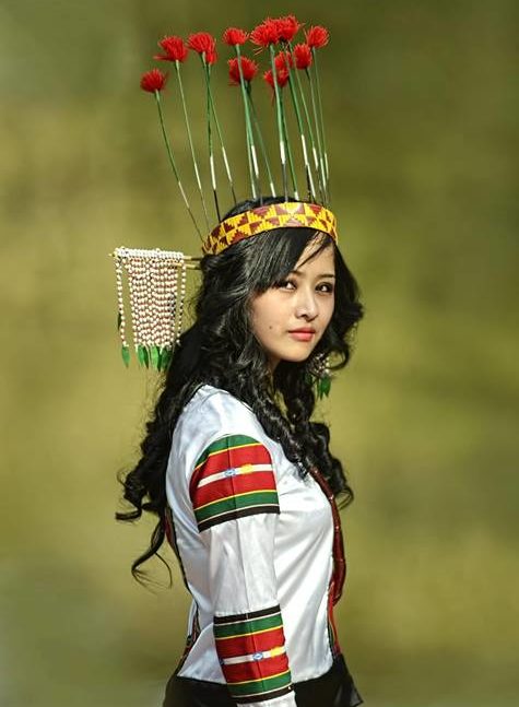
North East India Quick Information
The ever emphasized great Indian diversity of ‘life-forms, lifestyles and topography’ gets further accentuated in her northeastern flank. More so, in its deeper reaches. India’s prized dangler on the left looks almost a Southeast Asia enclave, geographically and ethnically, and is just connected to the Indian mainland via 20 km to 40 km Siliguri Corridor in West Bengal like a wattle between the neighboring China, Bhutan, Myanmar and Bangladesh. Northeast India is a jig-saw of natural and cultural splendors of its seven states, collectively labeled “The Land of Seven Sisters”, a quick recall of the region is dominated by the mighty Brahmaputra and waterways – the lifeline of the northeastern civilization; Rhinos, Hornbills and Orchids – the brand faces and graces; Tawang and Satras – centuries old learning and spiritual centers; Tea and tea gardens – the Indian national drink of international repute; around 225 tribes – maker and caretaker of the traditional colors; bamboo – grass that binds and weaves the region and lives therein. Cemeteries – reminders of the closest and bloodiest battles of the World War II. There’s much more to this. Majuli whose wetlands and satras give bird sanctuaries and world heritage sites respectively a run for their money. A Christian Tribal populace of Mizoram, Nagaland and Meghalaya which is not only about folklores and old customs but also about choir, rap and rock. The steep above clouds passes of Arunachal and the smooth carpet drives of the Shillong, the Scotland of the east. Birding and fishing at Nameri. Wettest places on earth, root bridges, tribal festivals and razzle-dazzle, world heritage national parks, picturesque rice fields, silk and crafts et al.
Assam Tourist Attractions – Tea Green Rhino Plains
Capital: Dispur
Main Languages: Assamese, Bengali,Bodo, etc.
Population: 26.6 million
Area: 78,483 sq km
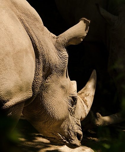
The lush green state of Assam is a 2000 year old civilisation blessed and checked by the great oceanic river Brahmaputra that originates as Tsangpo in Tibet and cut across Arunachal as Siang before braiding through Assam and rendering it flooded or fertile. Assam is the most accessible destinaiton of Northeast India. The present day Assam is the result of centuries of human fancy for and dictation of this inviting land and that shows in its top three attractions: Tea, Satras and Rhino. Tea is a colonial addition and today, besides being a major tea producer, Assam tea gardens, gardeners and cottages offers a unique culture and attraction. Satras are Neo-Vaishnavite learning centre of the 15th century and the repository of Assam’s art, craft and religious heritage over this period. Rhino, the one-horned heavyweight, is the face or mascot of many of state’s companies and products viz. cement, oil, boats and cruises, shops, sports events
| Name | Small Write Up | Highlights |
|---|---|---|
| Guwahati | Guwahati is a practical gateway to the northeast having air, rail and road connectivity to the rest and the northeast of India. However, for a first timer inspired by amazing stories and images of the ‘paradise unexplored’ the first impression at Guwahati may come as a shrilling wake-up alarm with the city’s noisy sub-urban commercial profile. This ‘area nut market’ (guwa + haat) of the yesteryears is presently bearing the brunt of being amongst the fastest developing cities of India, a commercial hub for Assam’s tea and oil industries and the largest and busiest city of the Northeast India. The capital of Assam, Dispur, lies in Guwahati only. Turned off? Don’t be for across the cityscape there are many local attractions and excursions to turn you on, like – Kamakhya temple, Umananda Temple, Assam State Museum, Sualkuchi and Hajo – all in the city astride the banks of mighty Brahmaputra river and bordered by the Neelachal hills. | Sualkuchi, Kamakhaya, Umananda, State museumGetting-there |
| Kaziranga National Park | Welcome to the rhino’s nation on the southern bank of Brahmaputra River, in Assam. A National park that stood and stands true to its objectives and can easily be called Assam’s greatest revived asset. A UNESCO World Heritage Site (1985), A Tiger Reserve (2006), Important Bird Area (Birdlife International) – Kaziranga is home to 1800 great one-horned rhinos, that is, two-third of world; world’s highest density of tigers with 32 tigers per 100 sq km; and India’s largest population of Asiatic wild buffalo.The above fact is the spin-off of a farsighted effort that focused on all elements of the food web and ecology. Meaning the above tiger statistics are not the result of blind in vitro mass production but an actual abundance of prey animals like hog deer, swamp deer, wild boar, hog badger, porcupine, sambar, wild buffalo, rhino and elephant. And it is not just the animals but also the birds that adds to Kaziranga being a wildlife lover’s delight. Around 300 species of birds have made Kaziranga their nesting, feeding or breeding place. Read more.. | 215 km North East of Guwahati Great One-Horned Rhino |
| Majuli River Island | Majuli is a setting…as if the nature’s idea and imagination of itself got a full play.”An island-world shaped by and drenched in the waters of Brahmaputra, peaceful, pollution-free, lush-green with pesticide-free rice-fields, dotted with fishing nets and traps, raised bamboo houses, home to simple tribal people busy in their chores of fishing, mask-crafts, pottery, handloom, boat-making and dairying, blessed with the spiritualism of the neo-Vaishnavites and their Satras, cohabited by many a flora and fauna, unusual or unseen in the civilized locales, with wetlands and swamps that offer a feast for many of its local and migratory birds, breeding ground for the gangetic dolphin (Shishu)…” Read more.. | Location:200 km to the east of GuwahatiBest Time: October to March
Must See: Neo Vaishnavites Satras, Mask-making, Villages, Bird watching |
Arunachal Tourist Attractions – Monastic Mist And Pastoral Charm

Capital: Itanagar
Main Languages: Many
Population: 1.1 million
Area: 83,743 sq km
The far northeast of India is the “Land of the rising sun” called as The Arunachal Pradesh, dominated by the Himalayas and graced by orchids. Overland towards Arunachal after negotiating serpentine hill-roads as soon as one reaches the high passes one realises that heaven is in store for him / her. One ‘wows’ a hundred time standing on these snow-covered high passes and see the white clouds from atop that look like ocean of smooth-cotton unfurling and settling around those high peaks. Therefrom, the place and its charm takes one through itself which lies in its pastoral life, monastic air and wilderness. Frozen lakes, forested ridges, alpine grasslands, grazing yaks, villages chores, bamboo-houses, gushing waters, fluttering prayer flags, settled rustic charm and all. Untouched till the recent times today Tawang, Ziro, Namdapha or Along finds a stamped mention on most northeastern itineraries.
Meghalaya Tourists Attractions – Scottish Highlands Washed And Fresh
Capital: Shillong
Main Languages: Khasi, Garo, Assamese,Bengali
Population: 2.3 million
Area: 22,429 sq km
The literal ‘abode of clouds’ was the summer asylum for the 19th century Britishers for whom its conifers, temperate, fresh, and cool climes came as a breather from the humid Assam valley. The mist and the clouds brace the undulating highlands of Meghalaya plateau especially at its capital Shillong for which reason the Britishers nicknamed Shillong as ‘The Scotland of the East’ and made it Assam’s capital. Shillong stayed so till the Meghalaya was carved from Assam in 1972. Meghalaya is bordered by Assam on north and east and the Plains of Bangladesh on south and west. Geographically or culturally it can be divided into Garo, Khasi and Jaintia, the three hill divisions named eponymously after the aboriginal tribes inhabiting them. Meghalaya salubrious climate washed with monsoons endows it with amazing diversity of flora and fauna. Its forests are one of the richest botanical habitats in Asia and have more than 350 Sacred Groves of India. 3000 species of orchids are found here out of 17000 in the world. Another highlight is the insect-eating pitcher plant. The prime destinations include Shillong and Cherrapunjee (Sohra) and Mawsynram which calls for a two-three day trip to explore both.
| Name | Small Write Up | Highlights |
|---|---|---|
| Shillong | The capital of Meghalaya is the place to experience Scottish highlands, pine, lakes, orchids, and waterfalls, clouds – a setting that inspires romance and romantic novelist of the likes of great Tagore. This well-spread modern hill-station sees Indian tourist buzzing around in its markets and attractions during summers. Westerners are mostly caught spelunking. A good thing is most attractions in and around Shillong are motorable. Located at a distance of 100 km form Guwahati Shillong can be the starting point of one’s Meghalaya journey. | Shillong View Point, Wards Lake, Golf Course, Museum, Catholic Cathedral, Archery, Cemetery & Church, and Elephant Falls. |
| Cherrapunjee | From Shillong, a scenic drive of 50 km on a carpet like road along the grassy moors upon the Meghalaya plateau takes one to the Wettest place on earth, Sohra, the local name of Cherrapunjee. Cherrapunjee is one of the best known destinations of Northeast India for its unrestrained monsoon showers. Watch out for the en route waterfalls, gigantic cliffs and rock formation sculpted by the heavy rains. | Mawkdok / Dympep Valley View (Midway between Shillong and Cherrapunjee), Sohra Market, Rama Krishna Mission Museum, Nohkalikai Waterfalls, First Presbyterian Church, Tombs of Welsh Missionaries, Anglican Cemetery, Thangkharang park, Eco-Park, Double Decker Root Bridge, Cherrapunjee Meteorological Observatory |
Nagaland Tourists Attractions
Capital: Kohima
Main Languages: Nagamese, English, Hindi, Other Naga dialects
Population: 2.4 million
Area: 22,327 sq km
| Name | Small Write Up | Highlights |
|---|---|---|
| Kohima | The capital of Nagaland, Kohima, at an altitude of 1500 m looks like any other Indian hill station at first look. A small pleasant town surrounded by hills and ridges dotted with villages. However, Kohima was once the site of one of the bloddiest battle during World War II and the cemetery of the martyrs is today the main attraction to the place.WW II Cemetery: “When you go home tell them of us and say, for your tomorrow we gave our today”. Thus reads the inscription on the World War II cemetery, Kohima’s prime attraction. 1200 Indian and British Soldiers laid down their lives fighting the invading Japanese Army. The signs of this 64-day battle can be seen across Kohima; however, in April 1944, it was here on the then deputy commissioner’s tennis court that the battle reached its final decisive point of short-range grenade fighting for 7-days. Overlooking this WWII cemetery is the Cathedral of Reconciliation which was built in the year 1995 with a part of funds given by the Japanese Government. | |
| State Museum, Kohima | Best place to get a peek into the Naga culture through the collection of its various artifacts. Among a rare collection of masks, jewelry and textiles what catches eye are a large ceremonial drum, elephant-jaw chair, Konyak brass figures, totem pillars, a diorama of Naga-lifestyle and a shawl design know-how section. | Fees: 5 INR,Time: 10:30 am – 3:30 pm) |
| Hornbill Festival | Time when the Naga wealth of heritage and its unique lifestyle come out of the museums, documentaries, images and good books and play and perform live for all. In fact, for a region now getting dressed-up by modernism and with troublesome access Hornbill fest is a one place to see all of the State’s colorful 16 tribes when its artist turn out in fancy dresses to perform and pose. The Hornbill fest is a week to celebrate the colors of human existence with dance, music, dramas, moods, costumes, drinks, food et al. The venue for the fest is Kisama heritage village, where lies the fascinating setting of a ‘once upon a time’ Nagaland in its open-air-museum. Traditional Morung (bachelor’s dormitory of the non-Christian period to learn traditional skills], Naga houses of bamboo and cane, decorated with artifacts like skulls, paintings, carvings to show-off, carved monoliths models, facades of the gatesy. | Time: 1-7 DecVenue: Kisama Heritage Village, 10 km from Kohima |
Manipur Tourists Attractions – Treasure House Of Culture And Nature’s Bounty
Capital: Imphal
Main Languages: Meitei (Manipuri), Assamese, Bengali
Population: 2.4 million
Area: 22,327 sq km
The ‘Land of Jewels’, literally, is the treasure-trove of rich culture of dance, theatre, martial arts, sports, cuisine and nature’s bounties. Braided by hills on all sides and 64% forests cover along with a salubrious climate make Manipur a pleasant home to the exotic flora, fauna and Vaishnavite Meiteis, the primary ethnic people also called as the Manipuri.
Manipur is the last natural refuge of the endemic Brow-antlerd Deer, Sangai, nearing extinction. Also for the flora Siroy Lily (Lilium macklineae) and Dzuko Lily (Lilium chitragade) alongwith many rare orchids and ferns that have abandoned the other parts of planet earth. The floating islands of Loktak lake, the life line of Manipur, is yet another marvel of ancient natural culture and civilization.
The honeymoonic Manipur borders Assam, Mizoram, Nagaland and Myanmar (Burma). The serene pleasant landscape, however, had to bear the wrath of time during the World War II with other states of Northeast. Like Nagaland, here too, the War Cemeteries are the crude and proud reminder of a Burma Campaign that shaped the Indian northeast.
Areas Open for International Visitors: Imphal city, Loktak lake, INA Memorial (Moirang), Sendra, Waithou Lake, Keibul Lamjao National Park and Khongjom War Memorial. Permits
| Name | Small Write Up | Highlights |
|---|---|---|
| Imphal | The capital of Manipur, Imphal, lies in the beautiful Imhal valley coursed by several rivers coming down from the hills skirting it. Imphal forms the base of one’s Manipur sojourn with regular fllights from Delhi via Guwahati and Kolkota. The tourists and travelers find Manipur’s rich past in its various monuments and temples.The sacred Govindajee Temple of Hindu Lord Vishnu is an ancient center for the Vaihnavites. The early-18th century twin shikhars of the temple lie adjacent to the royal palace of the Manipuri Maharajas of yore. The best time to visit the festival is during Holi (Dolijatra in Manipuri culture) when the youth turn up to perform the Thaba Changa folk dance during the evening. Besides Vishnu, the preserver, there are deities of Krishna and Balram.The World War II Cemeteries are yet another site to visit the heroic past. Equivalent to the ‘Battle of Kohima’, the ‘Battle of Imphal’ too was the turning point in the event. Thousands of British and Indian martyrs lie buried in these cemeteries.
Manipur State Museum can be a place to get short and smart insight into the Manipur’s marvelous royal and cultural past which stayed isolated historically or geographically. |
|
| Loktak Lake and Keibul Lamjao National Park | The otherworldly Loktak lake contains world’s only floating islands and a unique culture therein. The ancient Lake of Loktak is the largest fresh water lake in the North-East Region. The floating islands are actually floating phumdis which is a composte of decomposing vegetation, soil, and organic matters. Amongst its many floating islands the largest one is a National Park, called as Keibul Lamjao National Park (40 sq km) and obviously it is only one of its kind in the world. The brow-antelered deer or the dancing deer or Sangai is treasured here in its wild precincts. This small archipelago is of great socio-economic-and ecological importance to Manipur and especially to around one lakh people who reside on and around it dependent largely on lake fishery. One can get a panoramic view of the Loktak Floating Island world from atop Sendra Island hillock. | Distance: 42 km from ImphalTo visit: Sendra Island and Keibul Lamjao National Park |
Mizoram Tourists Attractions – The Joy Of Living
Capital: Aizawl
Main Languages: Mizo and English
Population: 8,95,000
Area: 21,081 sq km
Chibai, that’s how a Mizo smilingly greets you and for no apparent reason or rather a reason because of ethics deeply ingrained in their lifestyle. Mizo code of ethics Tlawmngaihna – meaning be unselfish, hospitable and helpful to each other – seems to be the push behind them being so cheerful and friendly. And perhaps it is this same unrestraint attitude which shows in their love for joyous dance, (there are 10 main dances), music, songs, colorful attires and being cool and hip. Mizos meaning the highlanders are the native of this state who migrated here some 300 years back from Chin hills of Myanmar and made this land their own and hence the name Mizoram, the land of the Mizos. They took to Christianity in the late 19th century, courtesy missionaries whose works after some initial identity dilemma and confusions let these tribal people express themselves to the outer world in an educated and refined way. Today, India has some of the finest choir singers and also the second most literate state in Mizoram.
Mizoram is the southermost state of the northeastern India and is huddled by her three sisters – Manipur, Assam and Tripura and neighbouring countries Myanmar and Bangladesh. Deep gorges, hills, bamboo green, gushing rivers and wilderness dominates Mizoram’s terra firma which is at an average altitude of 900 m. Among its many peaks the highest is Phawngpui, the blue mountain, which is revered as the abode of gods.
| Name | Small Write Up | Highlights |
|---|---|---|
| Aizawl | Aizawl the capital of Mizoram is also its political, religious and cultural center. Aizawl city with its timber houses look perched like a fortress along a steep ridge. From Aizawls height of approx 4000 ft one gets an amazing view of the emerald Tlawng River Valley in the west, the Turial River Valley in the east and the craggy hills of Durtlang in the north. |
Tripura Tourists Attractions – Royal Side Of Northeast
Capital: Agartala
Main Languages: Bengali, Kokborak and Manipuri
Population: 3.2 milion
Area: 10,486 sq km
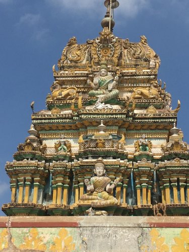
The third smallest state of India Tripura is a former independent princely state, like Manipur. Landlocked almost entirely by Bangladesh the ancient Kingdom is a tourists and travelers curio with its own cultural past and charming folklore of 3000 years and around 200 rulers and as varied as its name’s etymology which itself goes as far as the Hindu religious mythos go. Tripura finds mention in Mahabharata, the longest and one of the two important Sanskrit epics of Ancient India; in the Puranas, ancient Hindu religious text; and on the inscriptions of Ashoka Pillar, the 3rd century BC pillars erected throughout northern India by one of the greatest emperors of India, Ashoka.
Tripura, simply put ‘Three Loks or Three Worlds’, however, the roots of this simple meaning is a blend of facts and folklores and of interest to historians. The name ‘Tripura’ is believed to have originated from ‘Tripura Sundari’, the supreme deity of the state of Tripura which has one of the 51 Shakti Peeths, holiest Hindu shrine and center of Shakti worship, at Udaipur, like the Kamakhya temple in Guwahati, Assam. It may be legendary king Tirpur of Mahabharta whose name inspired Tirpura or it may be the fusion of two Kokborok words (kokborok alongwith Bengali is the official language of Tripura) Twi meaning water and pra meaning near, that is, the land adjoining water from the fact that the ancient kingdom of Tripura was well spread till the Bay of Bengal and there is a lot in the name.
Besides the nomenclature the ancient and medieval heritage of Tripura is expressed in its Hindu and Buddhist sculptures, rock cut reliquary of age-old idols of gods and goddesses, terracotta plaques and sealing, the animist-like Shakti Bhakti and temples, ethnic diversity of around 19 major tribes or clans, their dances, music, festivals, indigenous instruments like sarinda (Indian folk music lute) and sumui (flute); the Hojagiri dance of the Reang clan that’s done standing upon pitcher; folklores, customs, arts, handicrafts et al. The modern historical heritage lie in Tripura’s many palaces, bungalows and new temples and churches especially dotting the state capital Agartala.
Northeast India Permits- RAP, PAP, ILP
UPDATES 1st JAN 2011: Finally, To boost tourism:
Manipur , Mizoram and Nagaland scraps Protected Area Permit restriction [from 1 st jan 2011 for an initial one year period]
Assam , Meghalaya and Tripura Permits weren’t required
Arunachal Pradesh , however, still stays out of this relief in restrictions.
NB: THE PROTECTED AREA PERMIT SYSTEM IS LIFTED FOR AN INITIAL PERIOD OF ONE YEAR ONLY, THAT IS, 2011.
Northeast being a sensitve area along the border with southeast Asian countries and the ongoing insurgency issues, most northeast India states require tourists to obtain permits to visit them.
- RAP (Restricted Area Permit): Required for non-Indian citizens to visit certain areas in India
- PAP (Protected Area Permit): Required for non-Indian citizens to visit certain areas mainly in the North-Eastern region.Scrapped for an initial period ofone year
- ILP (Inner Line Permi): required for Indian citizens, who are not resident in these areas, to enter these places
Arunachal Pradesh Permits
• Indian tourists need an Innner Line Permit. This is available from any Government of Arunachal Pradesh office.
• Foreigners require a Protected Area Permit (PAP). The permit requirements were relaxed in 2008, and now only two or more people need travel together. PAPs are available for a duration of 30 days, and cost $50 per person. In reality, the best way of getting the PAP is though a travel agent. If you want to do it yourself, you can also readily obtain one from the Delhi Foreigner’s Regional Registration Office (East Block-VIII, Level-II, Sector-1, R.K. Puram, New Delhi). Apparently, other recommended government offices and Indian Embassies abroad aren’t particularly knowledgeable or helpful.
- Indian tourists visiting Manipur via Dimapur/Kohima require an Inner Line Permit to pass through Nagaland. This is available from any Nagaland House, or Government of Nagaland office.
- Foreigners require a Protected Area Permit (PAP) and must travel in groups of four or more people or as a married couple. PAP is valid for 10 days, and to limited number of places viz. Imphal city, Loktak lake, INA Memorial (Moirang), Sendra, Waithou Lake, Keibul Lamjao National Park and Khongjom War Memorial. Apply for the PAP at Delhi Manipur Bhawan (2 Dardar Patel Marg, New Delhi. Ph: +91 11 6870101). If you apply at the Guwahati Manipur Bhawan, expect to wait 2-4 weeks for your application to be processed. The application fee for a permit is 10 rupees, plus an additional 1,500 rupees per person if your permit is granted.
- Indian tourists need an Innner Line Permit. Aavailable at any Mizoram House and at Lenpui Airport.
- Foreigners require a Restricted Area Permit (RAP) and must travel in groups of four or more people or as a married couple. Valid only for 10 days and for limited areas. Permit can be obtained from the Government of Mizoram through Liaison Officers posted at New Delhi, Kolkata and Guwahati. For less than 4 persons, RAP has to be obtained from the Ministry of Home Affairs, Government of India.
- Indian tourists need an Innner Line Permit. This is available with deputy resident commissioner of Nagaland, Nagaland house, New Delhi/Kolkata or additional deputy commissioner at Dimapur.
- Foreigners require a Restricted Area Permit (RAP) and must travel in groups of four or more people or as a married couple. Valid only for 10 days and for limited areas. Apply for the RAP at the Foreigner’s Regional Registration Office in Kolkata or Indian Embassies abroad or the Ministry of Home Affairs, Govt. of India, New Delhi or Nagaland House in Delhi or travel Agents with a reasonable service charge.
Getting There
| Air | Rail | Road |
|---|---|---|
|
Lokopriya Gopinath Bordoloi International Airport at Borjhar, about 20 km west of the city center. Though the only International Flight to Bangkok is presently out of order the connection to other major domestic destinations is up and running. Guwahati is serviced with direct flights from Delhi, Jaipur, Indore, Mumbai, Kolkata, Hyderabad, Bangalore,Chennai and other major cities in India by different airlines. Helicopter service is operated by Pawan Hans from Guwahati to Shillong (30 min), Tura (50 min), Naharlagun (Itanagar), Tawang (75 min), etc. |
Guwahati Junction is the headquarter of the North-East Frontier Railway, one of the 16 railway zones of India responsible for entire railway operation in the Northeast and parts of West Bengal and Bihar. Guwahati Junction has a regular connection to all major Indian cities viz Delhi, Kolkata, Chennai, Bangalore, Bhubaneshwar, Mumbai, Kochi and New Jalpaiguri. The famous Rajdhani Express provide regular service to and from Delhi. The railway station connects Guwahati to other cities within the state as well. However, due to difficult terrains the network is okay till the Assam plains only. Further, the network is not broad gauge in many parts and suffers from slow speeds of around 30 Km/h. |
Outside seven states: Siliguri – 440; Kolkotta – 1100; Darjeeling – 630; Gangtok – 589; In seven states: Agartala – 600; Aizwal – 467; Tawang – 500; Kaziranga – 215; Itanagar – 420; Majuli – 314; Shillong – 120; Kohima – 339; Imphal – 484; Dimapur – 274; Jorhat – 303; Dibrugarh – 439; Tezpur – 180; National Highway 31 connects Guwahati with the states Bihar, Jharkhand and West Bengal. National Highway 37 from Goalpara in Assam to Dimapur in Nagaland traverses the entire length of Assam and connects Guwahati with almost all the major cities of Assam including the cities of Jorhat and Dibrugarh. |